GeoLogic Engine combines your shapefiles and business rules into a fast API and interactive map β delivering structured location-based decisions without GIS complexity.
Transform complex geospatial data into actionable business intelligence
Clickable maps that show your service areas, territories, and coverage zones. Let your team visualize and query location data instantly.
Clean REST endpoints that turn any address or coordinates into structured business logic. Integrate with your website, CRM, or internal tools.
Combine your polygons with custom rules to answer "what applies here?" β from service availability to territory assignments to eligibility checks.
From your data to instant business answers
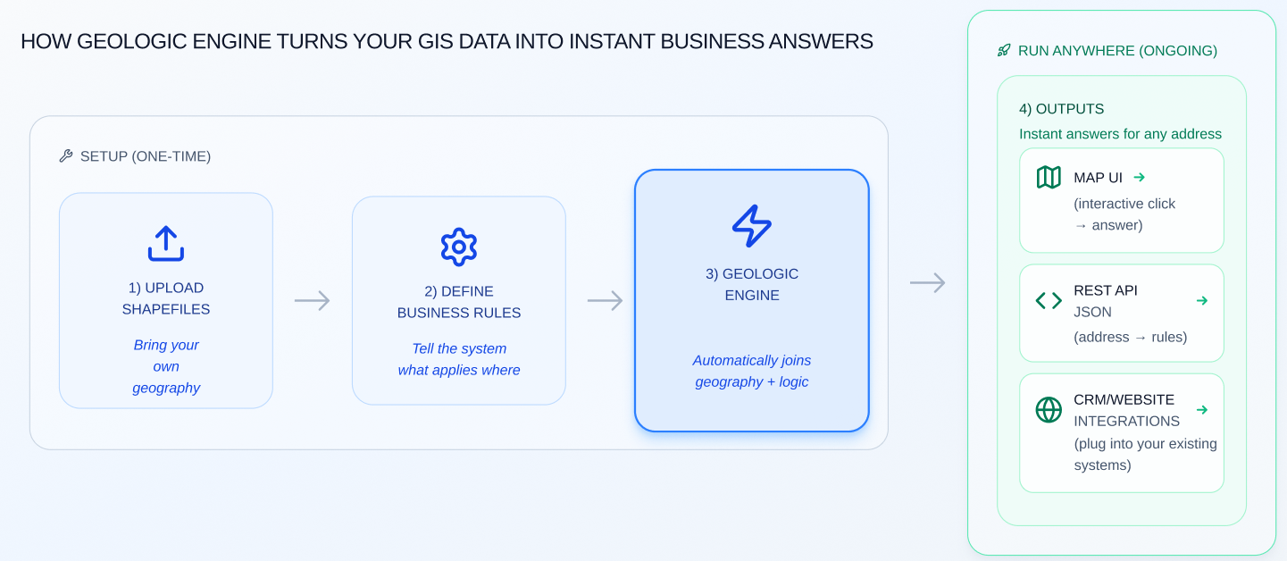
Upload your shapefiles and define your business rules once. We build and host the geospatial engine.
Get answers via interactive map UI, REST API, or direct CRM integration. Choose what works for your team.
When your service areas or rules change, just send new data. No rebuilding required.
GeoLogic Engine powers Hunterizer Maps, used by tens of thousands of hunters to instantly understand regulations at their exact location. The system processes millions of polygon intersections and rule evaluations with fast, reliable responses.
Fast, clean REST API for turning addresses into structured business logic
GET /api/seasons/v4/species_by_coordinates?lat=37.34&lon=-121.89&date=2025-12-07
{
"areas": [
{
"area": "nat-forest",
"zone_name": "Stanislaus",
"status": "hunting is generally allowed"
}
],
"species": [
{
"species_name": "quail",
"daily_bag": "10",
"shooting_hours": "30 minutes before sunrise - sunset",
"weapon_type_allowed": "Centerfire or muzzleloading shotguns, air rifle..."
},
{
"species_name": "turkey",
"daily_bag": "1",
"possession_limit": "2",
"shooting_hours": "30 minutes before sunrise - sunset"
}
// ... 46 more species with detailed regulations
]
}
Returns land ownership, hunting status, and 48 species with full regulations in milliseconds.
Whether you manage service areas, sales territories, eligibility zones, or coverage maps β GeoLogic Engine can turn your shapefiles and rules into instant answers.
One-time setup + monthly subscription starting at $99. Typical setups start at $1,000.